![]()
TOC > MSC data > Four Panel Aviation Package
Aviation Package (4-panel)
These prognostic charts for 6, 12, 18 and 24 hours (at 0000 and 1200) are produced by the regional run of the Global Environmental Multiscale (GEM) model. Forecasts are packaged as 4-panel charts as depicted below.
| Icing & Freezing levels | Tropopause heights & High level turbulence |
| Surface stress | Mid level turbulence |
- Area of coverage for all panels is as follows : North America and Arctic regions, North Atlantic, northern portions of Asia, and North Pacific.
- The transmission identifiers are as follows : CMC776, CMC777, CMC778, CMC779, CMC780, CMC781, CMC782, CMC783.
Example of a 4 panels chart in real time (12Z run, 6-hour forecast)
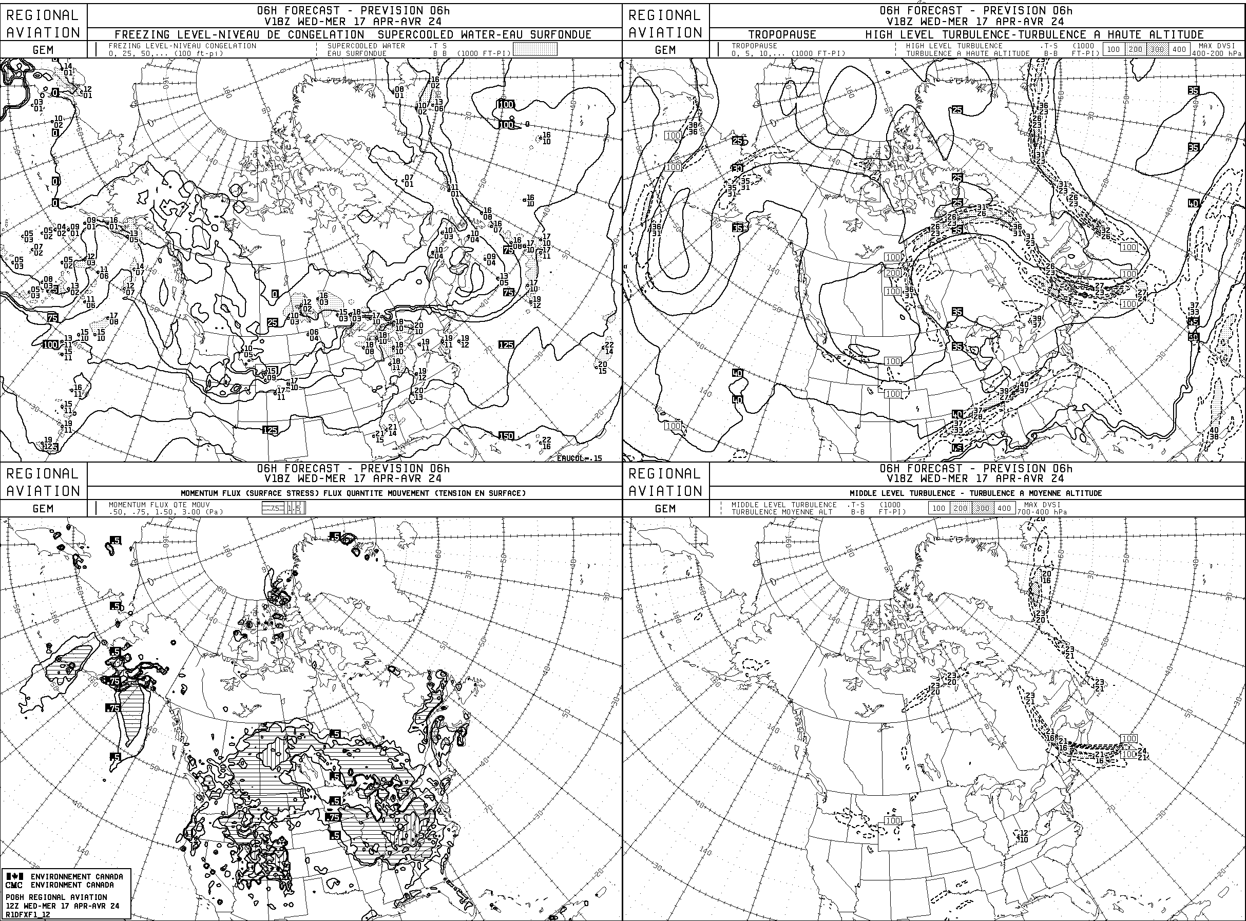
Icing and Freezing Level (top left panel)
Fields
- Freezing level
- Depiction: Solid lines of the height of the freezing level above mean sea level, at intervals of 2500 feet. The units are in hundreds of feet.
- Supercooled water (potential for icing)
- Depiction: Dashed lines delineate areas where model physics predict the presence of supercooled water droplets; these areas are further enhanced by a light stippling.
Plotting model
In the stippled areas, the base and top of the layer in which supercooled water is to be found, are plotted in thousands of feet above mean sea level, at selected grid points. The lower number gives the base and the upper number indicates the top of the layer.
High level turbulence and Tropopause height (top right panel)
Fields
- Tropopause height
- Depiction: Solid lines of the tropopause height above mean sea level, at intervals of 5000 feet. The units are in thousands of feet.
-
Turbulence (Deformation Vertical Shear Index or DVSI)
- Depiction: Dashed lines are the isopleths of the maximum deformation vertical shear index (DVSI) in the layer from 400 to 200 hPa.
- DVSI values are enhanced as follows:
- Lower than 200 : no enhancement
- 200 < DVSI < 300 : light stippling
- 300 < DVSI < 400: dark stippling
- DVSI > 400 : no enhancement
- DVSI values are enhanced as follows:
- Depiction: Dashed lines are the isopleths of the maximum deformation vertical shear index (DVSI) in the layer from 400 to 200 hPa.
-
Note: The WMO definition of the tropopause is used.
Plotting model
The base and top of the DVSI layer greater than 200 are indicated in thousands of feet above mean sea level, at selected grid points. The lower number is the base and the upper number is the top of the layer.
Momentum flux or surface stress (bottom left panel)
Fields
- Momentum Flux or surface stress
- Depiction: Isopleths of surface stress in Pa. The contoured values correspond to 0.5, 0.75, 1.5 and 3.0 Pa.
Note
Areas where the values of surface stress are above 0.75 Pa are hatched horizontally, while those where values of surface stress are above 1.5 Pa are hatched vertically. The values of 0.75 Pa represents the lower threshold for moderate mechanical turbulence; the value of 1.5 Pa represents the lower threshold for heavy turbulence and the value of 3.0 Pa is the lower threshold for extreme turbulence.
Mid level turbulence (bottom right panel)
Fields
- Turbulence (Deformation Vertical Shear Index or DVSI)
- Depiction: Isopleths of the maximum deformation vertical shear index (DVSI) in the layer from 700 to 400 hPa.
- DVSI values are enhanced as follows:
- Lower than 200 : no enhancement
- 200 < DVSI < 300 : light stippling
- 300 < DVSI < 400: dark stippling
- DVSI > 400 : no enhancement
- DVSI values are enhanced as follows:
- Depiction: Isopleths of the maximum deformation vertical shear index (DVSI) in the layer from 700 to 400 hPa.
Plotting model
The base and top of the DVSI layer greater than 200 are indicated in thousands of feet above mean sea level, at selected grid points. The lower number is the base and the upper number is the top of the layer.